Laser Rangefinder Binoculars for Forestry Management and Land Survey Applications
Modern forestry management and land surveying require accurate measurements, reliable observation tools, and efficient data collection methods. Whether managing forest resources, conducting environmental assessments, planning infrastructure projects, or performing topographic surveys, professionals need equipment that combines precision with field durability.
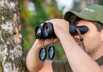
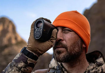
Laser Rangefinder Binoculars have become an essential tool for forestry professionals, surveyors, environmental consultants, and land management agencies. By integrating high-quality binocular optics with advanced laser ranging technology, these devices provide both clear observation and accurate distance measurement in a single compact solution.
Injie Optics develops professional laser rangefinder binoculars designed to meet the demands of forestry management, land surveying, and natural resource assessment projects worldwide.

The Importance of Accurate Distance Measurement
In forestry and surveying applications, measurement accuracy directly affects project quality and decision-making.
Professionals often need to:
- Measure distances between reference points
- Assess forest stand density
- Evaluate terrain features
- Conduct boundary inspections
- Monitor vegetation growth
- Plan land development projects
Traditional estimation methods can lead to errors that impact project outcomes. Laser rangefinder binoculars provide accurate measurements that support more reliable field data collection.
How Laser Rangefinder Binoculars Improve Field Efficiency
Observation and Measurement in One Device
Instead of carrying separate binoculars and distance measuring equipment, users can perform both tasks with a single device.
Faster Data Collection
Instant ranging results reduce survey time and improve productivity in the field.
Enhanced Accuracy
Laser technology provides precise measurements that improve project reliability and reduce uncertainty.
Improved Mobility
Compact designs allow professionals to travel more efficiently through forests, mountains, and remote work sites.
Applications in Forestry Management
Forest Inventory Surveys
Forestry teams use rangefinder binoculars to measure distances and assess tree distribution across large areas.
Timber Resource Evaluation
Accurate distance data helps improve forest resource planning and management decisions.
Reforestation Projects
Rangefinder binoculars support planting assessments and long-term forest monitoring programs.
Wildlife Habitat Assessment
Environmental specialists can evaluate habitat conditions while maintaining safe observation distances.
Fire Prevention Planning
Forestry authorities can monitor vegetation conditions and support risk assessment activities.
Applications in Land Surveying
Boundary Verification
Survey professionals use laser rangefinder binoculars to inspect property boundaries and verify reference points.
Topographic Observation
Distance measurements support terrain analysis and site evaluation projects.
Infrastructure Planning
Engineers and planners can assess project locations and collect preliminary site information efficiently.
Environmental Impact Studies
Rangefinder binoculars help researchers gather measurement data while minimizing environmental disturbance.
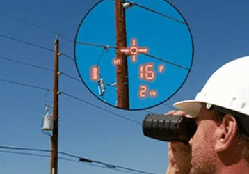
Utility Corridor Inspections
Professionals can monitor transmission lines, pipelines, and transportation routes from safe distances.
Key Features of Injie Laser Rangefinder Binoculars
High-Precision Laser Measurement
Advanced ranging technology provides reliable distance readings across a wide range of field conditions.
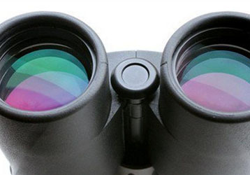
Superior Optical Clarity
Premium optical systems deliver sharp images and excellent visibility for long-distance observation.
Long-Range Performance
Designed for professional applications requiring extended observation and measurement capability.
Waterproof and Durable Construction
Built to perform in forests, mountains, wetlands, and challenging outdoor environments.
Lightweight Ergonomic Design
Comfortable operation supports extended use during field surveys and resource management activities.
Why Professionals Choose Injie Optics
Injie Optics combines optical expertise with advanced ranging technology to deliver dependable solutions for professional users.
Our products offer:
- High-accuracy laser ranging
- Long-distance measurement capability
- HD optical performance
- Fully multi-coated lenses
- Fast target acquisition
- Rugged outdoor reliability
- Long battery life
- Professional technical support
These features help users improve productivity and achieve more accurate results in demanding field applications.
Future Trends in Forestry and Survey Technology
Technological advancements continue to improve field measurement tools.
Future developments may include:
- GPS-integrated rangefinder binoculars
- Digital mapping compatibility
- Wireless data transmission
- AI-assisted terrain analysis
- Smart forestry management systems
- Cloud-based survey data collection
These innovations will further enhance efficiency and decision-making for forestry and land management professionals.
Conclusion
Laser Rangefinder Binoculars have become a valuable tool for forestry management and land survey applications. Their ability to combine accurate distance measurement with superior optical observation helps professionals collect reliable data, improve efficiency, and make better-informed decisions.
Injie Optics remains committed to developing innovative optical solutions that support forestry experts, surveyors, environmental professionals, and land management organizations worldwide.
About Injie Optics
Injie Optics is a professional manufacturer specializing in:
- Laser Rangefinder Binoculars
- Laser Rangefinders
- Thermal Imaging Devices
- Night Vision Equipment
- Professional Binoculars
- Electro-Optical Observation Systems
We provide advanced optical technologies that help professionals measure accurately, observe clearly, and work efficiently in every environment.