









Laser Rangefinders in Modern Forestry: Precision Tools for Smarter Forest Management
Forestry professionals face increasingly complex challenges, from sustainable resource management to environmental monitoring and wildfire prevention. Accurate field data is essential for making informed decisions, and laser rangefinders have become one of the most valuable tools for modern forestry operations.
INJIE Optics develops professional laser rangefinders designed to provide fast, accurate, and reliable measurements in demanding outdoor environments, helping forestry experts improve efficiency while minimizing manual measurement errors.
Why Laser Rangefinders Are Essential for Forestry
Traditional forestry measurements often require tapes, clinometers, or manual estimation methods, which can be time-consuming and less accurate over long distances.
Laser rangefinders simplify these tasks by providing instant digital measurements with minimal effort. Whether assessing a single tree or surveying an entire forest area, professionals can gather reliable data quickly and safely.
Key Forestry Applications
Tree Height Measurement
Accurate tree height measurement is crucial for:
Timber valuation
Forest inventory
Growth monitoring
Carbon storage estimation
Harvest planning
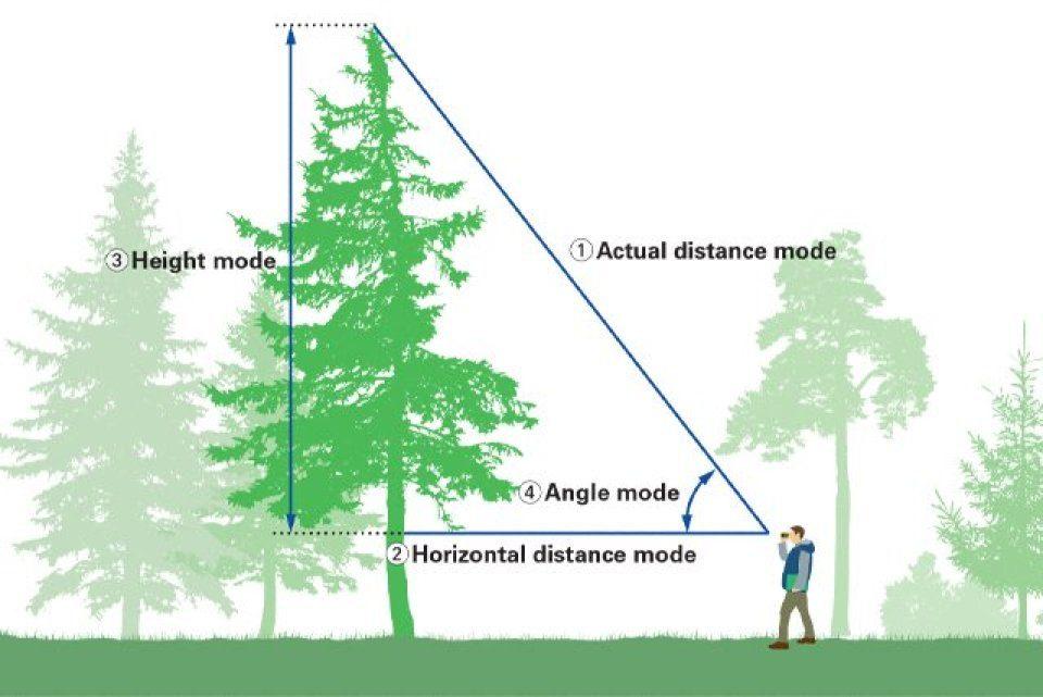
By combining laser distance measurement with angle calculation, users can determine tree height without climbing or approaching the tree.
Forest Inventory Management
Efficient forest inventories require consistent measurement of thousands of trees.
Laser rangefinders help forestry teams collect:
Tree spacing
Plot dimensions
Stand density
Canopy structure
Boundary distances
This information supports long-term forest management strategies.
Timber Harvest Planning
Before harvesting begins, forestry managers must accurately assess available timber resources.
Laser rangefinders assist in:
Estimating harvest zones
Measuring extraction routes
Planning machinery access
Reducing operational costs
Improving harvesting efficiency
Forest Boundary Surveying
Property boundaries and protected areas must be measured accurately to prevent disputes and ensure regulatory compliance.
Laser rangefinders provide quick distance measurements for:
Forest boundaries
Conservation zones
Plantation divisions
Wildlife reserves
Access roads
Wildlife Habitat Monitoring
Researchers use laser rangefinders to measure habitat characteristics without disturbing wildlife.
Applications include:
Nesting site assessment
Habitat mapping
Observation distance recording
Ecological research
Environmental monitoring
Features That Matter in Forestry
Forestry environments can be harsh and unpredictable. Professional users require equipment that performs reliably in rain, dust, heat, and rugged terrain.
INJIE Optics laser rangefinders are engineered with features such as:
Long-Distance Measurement
Measure distant targets across valleys, hillsides, and dense forests with confidence.
High Optical Clarity
Premium coated lenses provide bright, sharp images, making it easier to identify targets in low-light conditions or under dense forest canopies.
Multi-Function Measurement Modes
Professional forestry users benefit from functions including:
Line-of-sight distance
Horizontal distance
Vertical height
Angle measurement
Continuous scan mode
Lightweight and Portable Design
Compact construction allows users to carry the device comfortably throughout long field surveys.
Rugged Construction
Designed for outdoor use with:
Waterproof housing
Dust protection
Shock-resistant body
Ergonomic grip
Improving Forestry Efficiency
Laser rangefinders significantly reduce the time required for routine forestry measurements.
Benefits include:
Faster field surveys
Reduced labor costs
Improved measurement consistency
Better planning accuracy
Increased operational safety
By minimizing manual calculations, forestry teams can focus more on analysis and decision-making.
Supporting Sustainable Forest Management
Sustainable forestry depends on accurate data collection. Reliable measurements help organizations:
Monitor forest growth
Protect biodiversity
Plan responsible harvesting
Estimate carbon sequestration
Maintain ecological balance
Laser rangefinders contribute to more efficient and environmentally responsible forest management practices.
Why Choose INJIE Optics?
INJIE Optics combines advanced optical engineering with precision laser technology to provide dependable measurement solutions for professional users worldwide.
Our advantages include:
High-precision laser technology
Premium optical systems
OEM & ODM manufacturing services
Strict quality control
Durable outdoor design
Comprehensive technical support
Global export experience
Our laser rangefinders are trusted by professionals in forestry, surveying, engineering, security, utilities, and outdoor industries.
Conclusion
Modern forestry requires accurate data, efficient workflows, and dependable equipment. Laser rangefinders have become an indispensable tool for professionals seeking precise measurements in complex outdoor environments.
Whether measuring tree heights, surveying forest boundaries, planning timber harvests, or supporting environmental research, INJIE Optics Laser Rangefinders deliver the accuracy, durability, and performance needed to meet today's forestry challenges.
FAQ
How accurate are laser rangefinders for forestry?
Professional laser rangefinders provide highly accurate distance measurements, making them ideal for tree height calculation, forest inventory, and land surveying.
Can laser rangefinders work in dense forests?
Yes. High-quality optical systems and advanced laser technology allow reliable measurements even in challenging woodland environments.
Are INJIE laser rangefinders waterproof?
Many INJIE models are designed with waterproof and dust-resistant construction, making them suitable for demanding outdoor applications.
What industries use laser rangefinders besides forestry?
INJIE laser rangefinders are widely used in:
Construction
Surveying
Power line inspection
Mining
Security
Emergency response
Wildlife observation
Agriculture
Outdoor recreation